The fourth and most recent map, sponsored by NASA through the Subsurface Water Ice Mapping (SWIM) project, has been unveiled to pinpoint potential subsurface water ice locations on Mars. According to NASA officials, this map serves as a vital tool for mission planners in determining the optimal landing sites for the first human expeditions on the planet.
Since 2017, the SWIM project, spearheaded by the Planetary Science Institute and overseen by NASA's Jet Propulsion Laboratory, has been consolidating data from various NASA Mars missions to construct a comprehensive map indicating the likelihood of subterranean water ice in different regions of Mars.
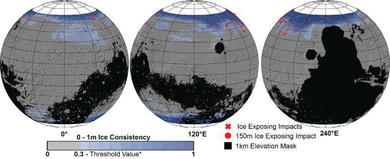
In the creation of this latest map, scientists relied on data from the Context Camera (CTX) and High-Resolution Imaging Experiment (HIRISE), both of which are instruments aboard the Mars Reconnaissance Orbiter. These instruments capture high-resolution images of the Martian terrain, allowing them to identify minute impact craters that may have exposed underlying "ice" or detect features like the "polygon terrain," characterized by ice thawing and refreezing with seasonal changes, resulting in distinctive ground fractures.
Identifying the presence of ice on Mars plays a pivotal role in planning crewed missions, requiring a delicate balance. Astronauts are keen to locate water ice as it offers a valuable source of water, reducing the need to transport large quantities from Earth. This suggests that the most suitable landing zones may be situated near the Martian poles. However, mission planners must also consider the temperature. Extreme cold would necessitate additional energy for maintaining crew warmth.
Sydney Do, the project manager for SWIM, commented, "When sending humans to Mars, the objective is to place them as close to the equator as possible." Ideally, this would entail a location with the lowest latitude that still provides access to ice. This is where Martian ice maps, like the ones created by SWIM, prove invaluable.
Furthermore, these maps offer scientists insights into the underlying reasons for Mars' distinctive characteristics. As Nathaniel Putzig, SWIM's co-lead at the Planetary Science Institute, pointed out, "The distribution of water ice in various Martian mid-latitude regions is not uniform; some areas appear to have more ice than others, and the reasons for these variations remain uncertain. The latest SWIM map may lead to new hypotheses explaining these disparities."