The enigmatic 1912 demise of the opulent ocean liner, the Titanic, has perpetually captivated the imagination of countless individuals.
Presently, historians hold the conviction that a recent endeavor involving underwater scanning holds the potential to shed light on lingering queries surrounding the calamity that claimed over 1,500 lives.
According to the announcement, scans of the Titanic wreckage were conducted during the summer of 2022 by a specialized vessel located 700 km (435 miles) off the Canadian coast. Stringent protocols were in place to ensure that the team refrained from any physical contact or disturbance of the wreck, emphasizing the utmost respect it deserved.
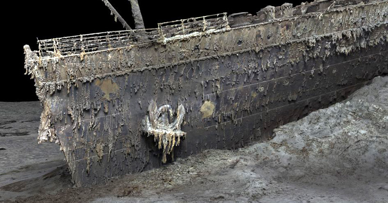
The press statement revealed that every minuscule aspect of the extensive debris field, spanning three miles, was meticulously mapped with precise detail. The ultimate digital replica successfully encompasses the entirety of the wreck, encompassing both the separated bow and stern sections since the sinking in 1912.
Parks Stephenson, a Titanic researcher with two decades of experience, lauded the project as a groundbreaking development that has brought to light "previously unseen details."
Stephenson expressed, "We now possess tangible data that engineers can utilize to analyze the actual mechanics behind the ship's structural failure and sinking, thereby drawing us even closer to uncovering the genuine narrative of the Titanic tragedy."
A notable instance of this newfound revelation can be observed on the propeller, where the serial number has resurfaced after being concealed for several decades.
During the expedition, approximately 715,000 images and a staggering 16 terabytes of data were collected, making it the most extensive underwater 3D model ever undertaken, estimated to be around ten times larger in scale than any previous endeavor of its kind, according to Richard Parkinson, the CEO of Magellan.
Parkinson characterized the undertaking as a "demanding" mission, highlighting the team's perseverance against formidable obstacles such as adverse weather conditions, technical hurdles, and the challenging elements.
In contrast to previous optical imagery of the sunken vessel, which suffered from limited lighting conditions and poor quality due to the depth of 12,500 feet underwater, the revolutionary mapping technique has effectively eliminated the water's interference and allowed optimal illumination, as stated in the press release.
According to 3D capture specialist Gerhard Seiffert, the exceptionally precise and lifelike 3D model has granted people the unprecedented ability to zoom out and observe the complete wreckage in its entirety for the very first time.
Seiffert further remarked, "The sight of the Titanic is now revealed in a manner that surpasses any previous perception."
Stephenson emphasized that this mapping endeavor would mark the "commencement of a new era" for Titanic investigation and exploration.