Google Maps is gearing up to introduce substantial artificial intelligence-driven enhancements in the coming weeks and months. Already appearing for select users, the five upcoming AI-supported features aim to empower users in confidently planning and navigating trips, making sustainable choices, and quickly finding inspiration for activities, according to Google.
Here's a preview of what to expect as these changes roll out:
 Immersive View
Users will have the capability to view a more comprehensive preview of every leg of their journey, whether it involves driving, walking, or cycling.
To visualize the entire route in a multidimensional view, users simply need to select their desired directions and tap the Immersive View preview.
This feature includes visual turn-by-turn directions and a time slider that aids in planning the optimal departure time, considering factors like simulated traffic and weather conditions.
According to Google, both iOS and Android users can currently experience this feature for trips in cities such as Amsterdam, Barcelona, Dublin, Florence, Las Vegas, London, Los Angeles, Miami, New York, Paris, San Francisco, San Jose, Seattle, Tokyo, and Venice.
.png) Lens in Maps
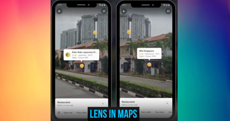
Lens in Maps
Lens in Maps, previously known as Search with Live View, employs artificial intelligence (AI) and augmented reality (AR) to provide users with insights into their surroundings and aid in orientation.
By tapping the Lens icon in the search bar and raising your phone, you can access visual information about nearby ATMs, transit stations, restaurants, coffee shops, and stores, whether you're exploring a new city or seeking out a local spot.
This feature, Lens in Maps, is undergoing its most extensive expansion to date, reaching over 50 new cities, including Austin, Las Vegas, Rome, São Paulo, and Taipei.
 Google Maps Navigation
Google Maps navigation is set to mirror the "real world" more precisely, thanks to advancements in AI. The forthcoming update will feature improved colors, lifelike buildings for better orientation, and updated lane details to assist with navigating through "some of the trickiest driving maneuvers" on highways.
These enhancements will soon be introduced in 12 countries, including the US, Canada, France, and Germany.
In the US, the navigation will now provide information about High Occupancy Vehicle (HOV) lanes on your route. Additionally, for Europe, AI-powered speed limit information is expanding to cover 20 countries.
 Electric Vehicle charging station information
Electric vehicle road-trippers can bid farewell to concerns about locating their next charging station. Drivers will now have access to additional information, including the compatibility of a charger with their vehicle, the charging speed (whether fast, medium, or slow), and the last usage time of the charger. These details aim to prevent wasted time and disappointment.
This update is currently being implemented "wherever EV charging station information is available."
Google Maps Unveils Enhanced Search for Inspirational Discoveries
Google Maps' updated search option aims to help users "find inspiration in a whole new way."
When searching for specific items, users will now receive photo-first results, leveraging the analysis of billions of photos contributed by the community on Google Maps. Simply tap on a photo to gather more information and explore further. The feature has commenced its rollout in France, Germany, Japan, the UK, and the US, with plans to expand to additional countries in the future.
Moreover, if you're feeling bored and uncertain about what to do, you can enter "things to do" in the search bar to access a list of thematic results that can be saved for later exploration. This globally rolling-out feature is expected to be available to users in the coming weeks.